


.jpg?#)


Summary of the 10th SWOT Applications Workshop
Introduction The tenth Surface Water Ocean Topography (SWOT) Applications Workshop took place December 7–8, 2023 at the California Institute of Technology Keck Institute for Space Studies. The meeting was organized to highlight the work and project status of the SWOT Early Adopters (EAs). NASA’s Applied Sciences Program (which is now housed within the NASA Earth […]


21 min read
Summary of the 10th SWOT Applications Workshop
Introduction
The tenth Surface Water Ocean Topography (SWOT) Applications Workshop took place December 7–8, 2023 at the California Institute of Technology Keck Institute for Space Studies. The meeting was organized to highlight the work and project status of the SWOT Early Adopters (EAs). NASA’s Applied Sciences Program (which is now housed within the NASA Earth Science in Action element of NASA’s Earth Science Division), the SWOT Project, the Centre National d’Etudes Spatiales (CNES’s), or French space agency’s SWOT Downstream Program, the SWOT Applications Working Group (SAWG), and members of the SWOT science community have coordinated efforts in support of the SWOT Applications Program since 2010.
The 2023 meeting, which was the latest in an annual series organized by the SAWG, welcomed over 100 participants online and in person during the two days, with many joining virtually across different time zones, to share their project status and explore the many facets of operational and applied uses of SWOT data. Presentations covered the current state of and near-term plans for using SWOT data products and highlighted related applied science efforts focused on SWOT. A significant focus explored the use of the new mission data to improve hydrology and ocean models.
After a brief introduction to SWOT and its instruments and a short update on the SWOT EAs, the remainder of this article contains a select group of summaries from EA projects. The complete meeting agenda and a list of presentations are available on the 10th SWOT Application Meeting website.
SWOT Mission Overview and Update
SWOT launched December 16, 2022, from Vandenberg Space Force Base in California. After a successful checkout of the satellite systems, instruments, and data systems, SWOT entered Science Mode on July 21, 2023. It continues to operate nominally as of this writing. A detailed account of SWOT Significant Events since launch is available online.
The goal of SWOT is to make the first global survey of Earth’s surface water, observe the fine details of the ocean’s surface topography, and measure how water bodies change over time. The international partnership is led by NASA and CNES, with contributions from the U.K. Space Agency and the Canadian Space Agency.
The SWOT Science Team is made up of researchers from all over the world with expertise in oceanography and hydrology. Together the team is using SWOT data to study a range of topics, including availability of Earth’s freshwater resources and our changing ocean and coasts. Studies like these are crucial to meet society’s growing needs for clean air and water, to help prepare for and mitigate impacts of extreme weather, and to help the world adapt to long-term changes in climate on continental scales.
SWOT’s payload has been designed to provide the data that allow the SWOT team to study the topics listed in the previous paragraph. While the complete compliment of instruments is listed on the website, the three most relevant to the current article are described here.
- Ka-band Radar Interferometer (KaRIn). This state-of-the-art, wide-swath, interferometric radar can measure the ocean, major lake, river, and wetland levels over a 120-km (75-mi) wide swath with a ~20-km (~12-mi) gap along nadir, which is filled by the Jason-class altimeter described below. KaRIn can operate in two modes: It uses low-resolution mode over the ocean with significant onboard processing to reduce data volume; and high-resolution mode over broad, primarily continental regions defined by the SWOT Science Team, where the focus is on hydrological studies as opposed to oceanographic ones.
- Jason-class Altimeter (nadir altimeter). The altimeter flying on SWOT is similar to those flown on the series of ocean surface topography missions that have operated since 1992, including the (TOPEX)/Poseidon, Jason-1, Jason-2, and Jason-3 missions, and the newest mission, Sentinel 6 Michael Freilich (S6MF), developed in partnership with the European Space Agency (ESA). The altimeter sends and receives signals that travel straight up and down beneath the spacecraft (or nadir-pointing) making it ideal to fill in the “gap” between KaRIn swaths.
- Microwave Radiometer (radiometer). This radiometer measures the amount of water vapor between SWOT and Earth’s surface. More water vapor present in the atmosphere slows down the radar signals and this instrument aids in correcting the signal.
SWOT’s sea surface height (SSH) measurements will be added to the existing 32-year time series of measurements of oceans and large water bodies compiled by the series NASA–CNES altimetry missions listed above. With higher resolution observations, SWOT will enable hydrological research and applications and provide more detailed information on heights and extent of rivers, lakes, reservoirs, and wetlands, as well as derived parameters such as river discharge.
SWOT Early Adopter Overview and Update
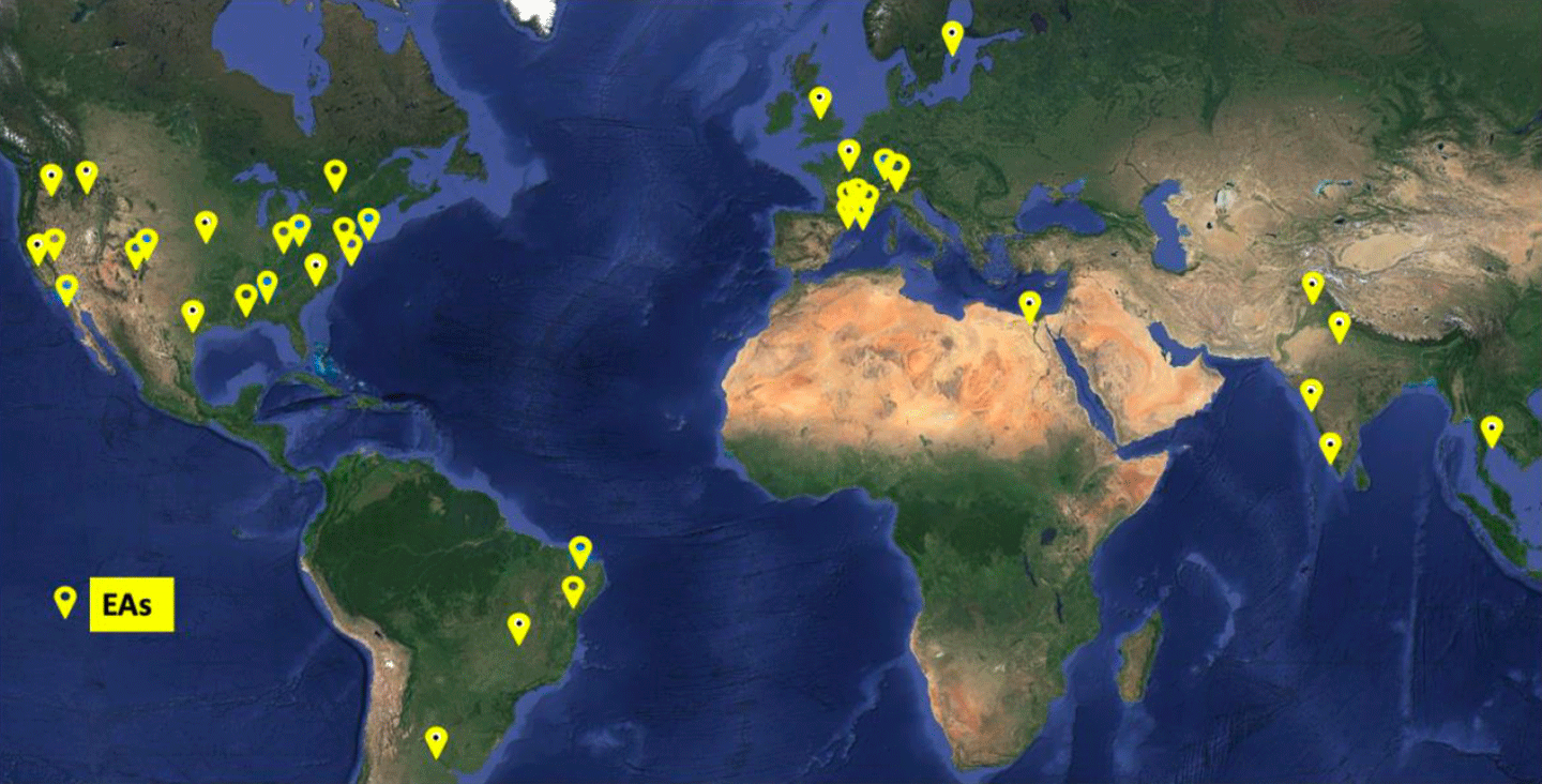
The SWOT Early Adopters Program was initiated in 2018 to ensure community preparedness to make use of SWOT data. The program comprises a growing community working to incorporate SWOT data into the operational and applied science activities of their organizations – see Figure 1. The current SWOT EA cohort spans surface hydrology and oceanography domains and organizations, including both U.S. and international private-sector companies, academia, nonprofits, operational agencies, state and national government organizations, and research communities.
The 2023 SWOT Applications Workshop offered an opportunity to assess how the SWOT user community is using the data in anticipation of future SWOT data reprocessing and releases. The 2023 meeting explored three themes: 1) planned and current operational and applied uses of SWOT data; 2) the current state of the data products and access to the data; and 3) a variety of other projects that may/will include SWOT data in their applications.
The first public release of SWOT data came in June 2023, with the release of nadir altimeter and radiometer data. These data had a head-start in processing due to the instrument and processing heritage. These early releases allowed the EA community to begin incorporating SWOT into their operational models and systems. A public release of beta pre-validated SWOT KaRIn data products took place in November 2023, and the subsequent public release of pre-validated SWOT KaRIn data products in February 2024. SWOT KaRIn, nadir altimeter, and radiometer products are now in operational production and routinely available.
Workshop Overview
This workshop focused on the achievements of the SWOT EAs, offering a platform to share their projects with the community as they transition from “early adoption” to simply “adoption” of SWOT as a valuable resource in their system management toolbox. In addition, the meeting provided a space for discussions, an increased community awareness of the gaps and challenges of incorporating SWOT data into operational and decision-support framework for models, modeling systems, and other operational uses. Feedback from these discussions – especially concerning the known limitations of SWOT data with respect to data latency and mission length – will be exceptionally useful to the SWOT Project and Applications Teams.
Meeting Welcome and “Keynote” Presentations
Brad Doorn [NASA Headquarters (HQ)—Programmatic Lead], Annick Sylvestre-Baron [CNES—Programmatic Lead], Parag Vaze [JPL—SWOT Project Manager], and Pierre Sengenes [CNES—Project Lead] gave remarks to open the meeting. They welcomed attendees on behalf of NASA and CNES.
The first morning session closed with two highly relevant and illuminating presentations. Jinbo Wang [JPL] spoke about SWOT KaRIn performance and calibration/validation (Cal/Val) activities. Curtis Chen [JPL] detailed critical and important proclivities of KaRIn data products that EAs may find beneficial as they interpret data results. Understanding the information in Chen’s talk is critical for those planning to use the data.
SWOT Early Adopter Project Updates
The EA project summaries selected for this article provide an overview of the range and depth of the extensive work accomplished by the SWOT EA community to date. These examples illustrate the potential of SWOT data as a tool to manage surface water resources and forecast ocean and coastal conditions via operational systems in the coming years.
Daniel Moreira [Brazil Geological Society (BGS)—Project Investigator] explained that the current gauge network on rivers across the Amazon basin is limited. SWOT data offers unprecedented spatial and temporal coverage of water storage processes and may be beneficial to prepare for floods and extreme events in the basin. Moreira’s group has compared several sites using Global Navigation Satellite System data and a gauge station elevation time series with very good results. In addition, BGS maintains a weekly water level report and a web application that leverages satellite altimetry data from the S6MF and Jason-3 missions for comparison across the Amazon Basin. BGS plans to produce discharge datasets over the Amazon using altimetry.
Isabel Houghton [Sofar Ocean] introduced the Sofar Ocean ship route optimization and navigational safety platform, incorporating 10-day, data-assimilating marine weather forecasts. That data includes significant wave height estimates from both the Sofar spotter buoy network and estimates derived from nadir altimeters on NASA’s S6MF and Jason-3 missions and the joint CNES–Indian Space Research Agency (ISRO) Satellite with ARgos and ALtiKa (SARAL) satellites. (Argos collects data from a floating oceanic buoy network with the same name that CNES operates; AltiKa is a CNES-contributed Ka-band altimeter.) TheWaveWatch III model improves on the forecast through the addition of altimeter data. Houghton explained that Sofar Ocean is in the preliminary stages of using SWOT significant wave height data in their model, which is less noisy than the predecessor altimeters reducing forecast error. Sofar expects SWOT to improve their observation numbers by 50–100% in a given 24-hour period. Additionally, Sofar plan to use KaRIn observations in an Earth system model under development to address waves, circulation, and atmosphere.
Robert Dudley [U.S. Geological Survey (USGS)] presented a project that involved the team integrating data from SWOT and in situ sources together to derive discharge and flow velocity for the Tanana and Yukon Rivers in Alaska. The USGS is collaborating with the Physical Oceanography Distributed Active Archive (PO.DAAC) to integrate SWOT in SatRSQ measurements to develop the Water Information from Space (WISP) dashboard to access time series of SWOT hydrology products. WISP is in development and not yet publicly available. When operational, it will enable comparisons with collocated, ground-gauged time series. WISP contains SWOT orbital ground tracks and will add the SWOT lake database in the future. The dashboard should be publicly available later in 2024.
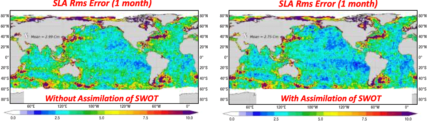
Gregg Jacobs [U.S. Naval Research Laboratory (NRL)] explained how NRL has evaluated SWOT KaRIn SSH data accuracy and integrated it into ocean forecast models by characterizing along-track errors in early data products to determine the necessary corrections. Jacobs then explained how the team computed daily interpolation of nadir altimeter data at SWOT crossover locations. They found good agreement between the corrected SWOT estimates and interpolated SSH from nadir altimeters and conducted ocean forecast experiments on California SWOT crossover Cal/Val sites – see Figure 2. NRL has had success in assimilating KaRIn data at a resolution of 5 km (~3 mi).

Pierre Yves Le Traon [Mercator Ocean International (MOi)] explained that MOi is a non-profit that is now transforming into an intergovernmental organization. He began with a description of the Copernicus Marine Service, which is a long-term partnership between CNES, MOi, and a French company called Collecte Localisation Satellites (CLS) that focuses on ocean monitoring and forecasting. SWOT data will be used to constrain small scales in models – see Figure 3. The preliminary results are in good agreement with CNES Level-3 (L3) products. SWOT KaRIn data will be integrated into the operational Copernicus Marine Service operational forecast portfolio in 2025.
Guy Schumann [Water in Sight]explained this Swedish start-up company uses SWOT data to validate in situ gauge data in Malawi. Gauge readers and observers collect data at monitoring stations from south to north Malawi to support the government’s efforts in managing water and climate risks. They have used free Short Message Service and leveraged citizen science to develop a cloud platform for data access. For the next step, the project plans to integrate SWOT data into two-dimensional (2D) flood models. This EA project aims to address latency – time delay between collection and transmission of data – and interoperability challenges, enhancing hydrological network optimization as well as demonstrating the diverse complementary value of satellite observations. The group supports codesigned joint explorations, engagement activities, and technology alignment. The CNES hydroweb tool may be very useful in this endeavor, but Schumann acknowledges that there are interoperability challenges that need to be overcome.
Jerry Wegiel [NASA’s Goddard Space Flight Center] explained that the U.S. Air Force’s Weather Land Information System (LIS) is a software framework used by multiple agencies for simulating land/hydrology processes. The Global Hydrology Intelligence (GHI) system (rebranding of LIS) is a comprehensive framework for hydrologic analysis, forecasting, and projections across scales encompassing all aspects of water security and addressing significant hydro-intelligence gaps identified by the defense and national security communities. Integration of SWOT L2 products operationally into the LIS Hydrological Modeling and Analysis Platform (HyMAP) model is expected to improve the global hydrological model data analysis system, as well as improve extreme hydrological event monitoring, reduce forecasting uncertainty, and support water security conflicts.
Alexandre de Amorim Teixeira and Alexandre Abdalla Araujo [both at Agência Nacional de Águas e Saneamento Básico (ANA), or Brazilian National Water and Sanitation Agency] began by explaining that the ANA hydrography datasets [e.g., Base Hidrográfica Ottocodificada (BHO)] and water atlases [e.g., Base Hidrográfica Atlas-Estudos (BHAE)] have been extended using information from the SWOT River Database (SWORD) river reaches, which are roughly 10 km (~6 mi) SWORD-specified sections of a river, in Brazil – see Figure 4. By incorporating SWORD data into the BHAE, over 400,000 reaches have been identified – compared to 20,000 identified previously using SWORD alone. The latest version (6.2) of BHO will combine SWORD and BHAE data increasing numbers exponentially to nearly 5.5 million. The ANA EA project will use SWOT data to support water resource management in Brazil. ANA is working in collaboration with University Brasilia to integrate available gauge information on rivers and reservoirs to fulfill their mandate to determine and report on water availability in the country. They described a sophisticated hexagonal hierarchical geospatial indexing system that will support hydrological and hydrodynamical modeling and cross-validation. The team will use SWOT data pixel cloud or raster products to best serve their needs.

Data Systems and Products for Early Adopters
In 2021, the SWOT Project Science Team made simulated datasets available for select hydrologic and oceanographic regions. These datasets shared many characteristics in common with future SWOT data products (e.g., formats, metadata, and data contents) and were intended to familiarize users with the expected SWOT science data products.
At this meeting, teams from both the NASA and CNES mission data system and data repositories shared timely and valuable information and updates with the EA community. The talks provided information and insight into what users can expect from SWOT products.
Lionel Zawadzki and Cyril Germineaud [both at CNES] described the use of SWOT data available from CNES through the AVISO (ocean and coastal) and hydroweb.next (hydrology and ocean) data portals. Systems supporting data access include data acquisition and production, data repositories, and ultimately cloud data access through thematic portals.
Catalina Taglialatela and Cassandra Nickles [both at JPL] discussed the use of KaRIn high-resolution and low-resolution SWOT data products available through PO.DAAC, which provides centralized, searchable access that is available using an in-cloud commercial web service through the NASA EarthData portal. The team demonstrated resources and tutorials available via the online PO.DAAC Cookbook: SWOT Chapter, as well as the new Hydrocron SWOT time series applications programming interface (API) for generating time series over water features identified in SWORD and SWODLR, which is a system for creating on-demand L2 SWOT raster products.
Shailen Desai [JPL] explained how KaRIn products depend on upstream orbit, attitude, and radiometer products for optimal accuracy. SWOT KaRIn, nadir altimeter, and radiometer products are now in operational production and routinely available. Product description documents and SWOT algorithm theoretical basis documents are all publicly available.
Curtis Chen [JPL] discussed how the SWOT science data system team have reduced complexities of the KaRIn measurements to ensure robust interpretation of the results. Knowledge of measurement details may be especially important in trying to interpret the pre-validated data products. During his presentation, Chen addressed practical aspects of interpreting KaRIn data products, including answers to frequently asked questions and tips to avoid confusion and misinterpretation in using the data.
Yannice Faugere [CNES] explained how CNES will assimilate SWOT data into Mercator Ocean with value-added elements, including multimission calibration, noise mitigation, and images that blend KaRIn and nadir instruments. A preliminary assessment of L4 products was conducted using one-day Cal/Val orbit measurements with promising results. Tests on 21-day data and an L4 data challenge for community feedback to compare mapping and validation methods are in process.
Complementary Projects
Participants spoke about a number of other projects and programs during the meeting. The selected presentations address elements relevant to SWOT applications.
Charon Birkett [NASA] discussed how SWOT data will be incorporated into the Global REservoir and LAke Monitor (G-REALM) and Global Water Measurements (GWM) portal, to integrate nadir radiometer and KaRIn measurements. G-REALM maintains a 30-plus-year time series of nadir altimeter data from the NASA/CNES reference missions for this measurement (i.e., Topex/Poseidon; Jason -1, -2, and -3; and S6MF) as well as the European Remote Sensing Satellite. GWM is focused on lakes and reservoirs, rivers, and wetland water levels to derive surface extents and storage change.
Stephanie Granger [JPL] introduced the Western Water Applications Office (WWAO), which provides NASA data, technology, and tools for water management to water managers in the western U.S. The WWAO team completes needs assessments for basins – a task complicated by the more than 100 agencies involved in water management activities in the western U.S. Granger identified several activities that could benefit from SWOT data, such as extreme event predictions and impacts, timely streamflow predictions at a sub-basin level, wet/dry indicators from streamflow monitoring, and flood plain mapping.
Babette Tchonang, Dimitris Menemenlis,and Matt Archer [all from JPL] presented a study that evaluates the feasibility of applying the Estimating the Circulation and Climate of the Ocean 4-Dimensional Variational (MITgcm-ECCO 4DVAR) data assimilation framework to a sub-mesoscale resolving model [grid resolution of 1 km (~0.6 mi)] in preparation for future studies to assimilate SSH measurements from SWOT. Two model solutions are nested within the global 1/12° Hybrid Coordinate Ocean Model (HYCOM)/Navy Coupled Ocean Data Assimilation (NCODA) analysis. Comparing the two model solutions against assimilated and withheld in situ observations indicates that the MITgcm-ECCO 4DVAR framework can be applied to the reconstruction of sub-mesoscale ocean variability. This data assimilation system is now being used by the Scripps Institution of Oceanography to support SWOT post-launch activities.
Matt Bonnema [JPL] presented the Observational Products for End-Users from Remote Sensing Analysis (OPERA) project, which produces a suite of surface water extent products, such as Dynamic Surface Water extent (DSWx). The products are based on a variety of optical and radar sensors built on existing satellite data that are freely available from NASA. DSWx gives two dimensions of surface water measurements (i.e., spatial extent), whereas SWOT produces three dimensions of surface water measurement (i.e., spatial extent and elevation). DSWx has the potential to fill in temporal gaps in SWOT observations and to cross-compare DSWx and SWOT when observations are concurrent. DSWx is a valuable source of global water information that can be used to interpret and enhance SWOT’s capabilities.
Renato Frasson [JPL] explained how the U.S. Army Corps of Engineers support the National Geospatial-Intelligence Agency (NGA), which uses water storage and lake/reservoir flux information primarily from NASA’s MODerate resolution Imaging Spectroradiometer (MODIS) that flies on both the Terra and Aqua platforms. SWOT data has a higher spatial resolution for river widths, and NASA–ISRO Synthetic Aperture Radar (NISAR) observations are planned to be incorporated into the OPERA platform.
Cedric David [NASA/JPL] discussed how SWOT data can improve state-of-the-art hydrologic models to address environmental and societal challenges in river system science (e.g., flooding, water security, river biodiversity, changing deltas, and transboundary issues). Model advancements (e.g., U.S. National Water Model) can be realized in areas such as uncertainty quantification, data assimilation, bias correction, and decreasing numbers of in situ observation systems. Incorporating SWOT data into river models will lead to more realistic representations of these rivers, which in turn will improve the users’ ability to understand and effectively manage these critical and threatened water resources.
Workshop Recommendations and Feedback
This 2023 SWOT Applications Workshop provided an opportunity to share early experiences with SWOT data and insight into integration of the data into operational and decision-support workflows and models (e.g., ocean circulation and hydrologic, hydrodynamic, and decision support). Understanding how EAs integrate SWOT data and the associated challenges is critical to provide a clear analytical path for assessing the value of SWOT’s observations.
Integrating satellite observations into models enhances the model’s capability to forecast natural phenomena and monitor remote or inaccessible regions, expanding modeling capabilities dynamically and spatially. The EA-user community shared information on the potential of incorporating SWOT data into local- or community-wide models or modeling systems. SWOT’s high-resolution data – particularly from the KaRIn instrument – can enhance the precision of hydrology and ocean models by enabling detailed simulations of water dynamics. This includes accurate mapping of freshwater bodies and SSH. Both these measurements are crucial for managing water resources, predicting floods, and understanding ocean circulation patterns. The incorporation of SWOT data into model systems enables significant advancement and insights that can inform environmental management policies and practices by supporting more informed decision-making.
Although the SWOT nadir altimeter data products are being operationally produced and distributed through the data centers, the new data products from the novel KaRIn instrument continue to be assessed. An entire year of data is necessary for a more comprehensive assessment of value, ease of use, and degree to which SWOT data will impact operations and decision-making.
Throughout the workshop, EAs shared their experiences and specific needs in regard to early use of SWOT data in their modeling frameworks. Overall impressions were positive, but the actual use of SWOT beta product data was limited to a few projects (e.g., NRL, Sofar Ocean, and Copernicus Marine Service). Overall, the meeting participants supported the need for lower-latency products.
In the coming year, the impact of SWOT data with lower 21-day science orbital repeat frequency and latency on various applications will be understood further. Ultimately, the most important feedback from SWOT EAs is yet to come.
SWOT has the potential to provide invaluable information to operational user communities through its ability to advance understanding of global surface water dynamics. The SWOT Applications Program has successfully engaged a diverse cohort of agencies and the commercial sector to support integrating SWOT data into operational workflows. Moving forward, the program aims to highlight societal benefits, support applied research in hydrology and oceanography, expand user engagement, and provide ongoing training to maximize the effective use of fully validated SWOT data products.
Conclusion
The 2023 SWOT Applications meeting was a successful and timely engagement opportunity, further strengthening the connection between the different collaborating organizations. Many EAs demonstrated early ingest of the preliminary release of KaRIn data, with some having already started using the nadir altimeter data in their operational processes. Engagement will continue as more data, including pre-validated and validated science products, become regularly available with support to the EA community.
Future SWOT Application activities will include continued communication at community meetings and conferences as well as with a broader audience to engage new users for both applied research and operational activities through workshops, hackathons, and telecons. The SAWG will continue working with EAs and the applied and operational user communities to identify and apply value of SWOT to support decision makers and operational agencies.
NASA and CNES data distribution centers will continue to train users in cloud data access, data formats, and preferred formats for different topics, as well as provide EA feedback to improve data products and platform services. NASA and CNES will continue to work with EAs to overcome technical hurdles, help complete their projects, and generate high-impact success stories, as well as expand the extent of SWOT EAs and applied science users to build recognition of SWOT among practitioners.

Acknowledgment: The author wishes to acknowledge the contribution of Stacy Kish [NASA’s Goddard Space Flight Center (GSFC)/Global Science and Technology, Inc. (GST)] for her editing work to reduce/repurpose the full summary report to create a version suitable for the context of The Earth Observer.
Margaret Srinivasan
NASA/Jet Propulsion Laboratory, California Institute of Technology
margaret.srinivasan@jpl.nasa.gov
Share
Details
Related Terms
What's Your Reaction?