


.jpg?#)


NASA Uses Advanced Radar to Track Groundwater in California
NASA’s radar-equipped jet is detecting ground movements to track snowmelt’s journey into California’s depleted groundwater aquifers.
NASA Uses Advanced Radar to Track Groundwater in California

Bureau of Reclamation
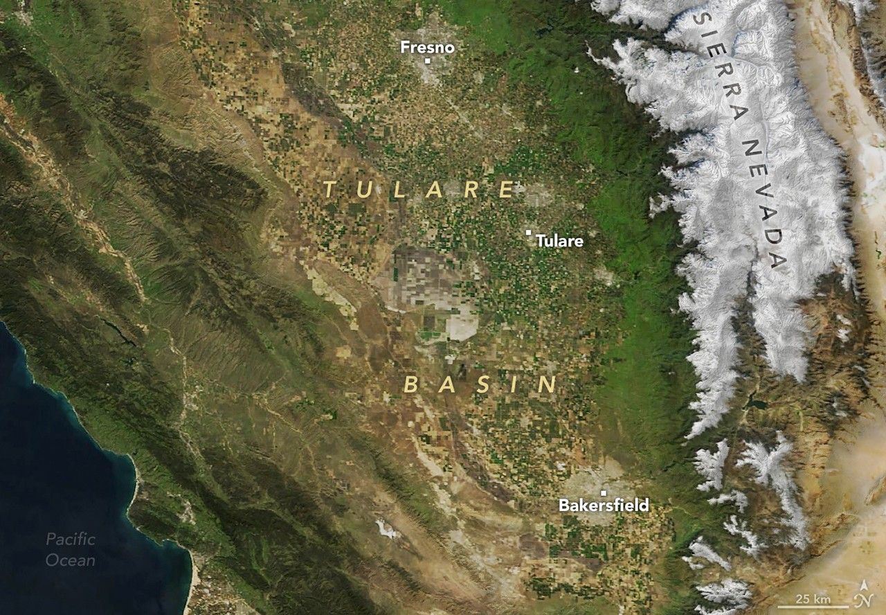
Where California’s towering Sierra Nevada surrender to the sprawling San Joaquin Valley, a high-stakes detective story is unfolding. The culprit isn’t a person but a process: the mysterious journey of snowmelt as it travels underground to replenish depleted groundwater reserves.
The investigator is a NASA jet equipped with radar technology so sensitive it can detect ground movements thinner than a nickel. The work could unlock solutions to one of the American West’s most pressing water challenges — preventing groundwater supplies from running dry.
“NASA’s technology has the potential to give us unprecedented precision in measuring where snowmelt is recharging groundwater,” said Erin Urquhart, program manager for NASA’s Earth Action Water Resources program at NASA Headquarters in Washington. “This information is vital for farmers, water managers, and policymakers trying to make the best possible decisions to protect water supplies for agriculture and communities.”
Tracking Water Beneath the Surface
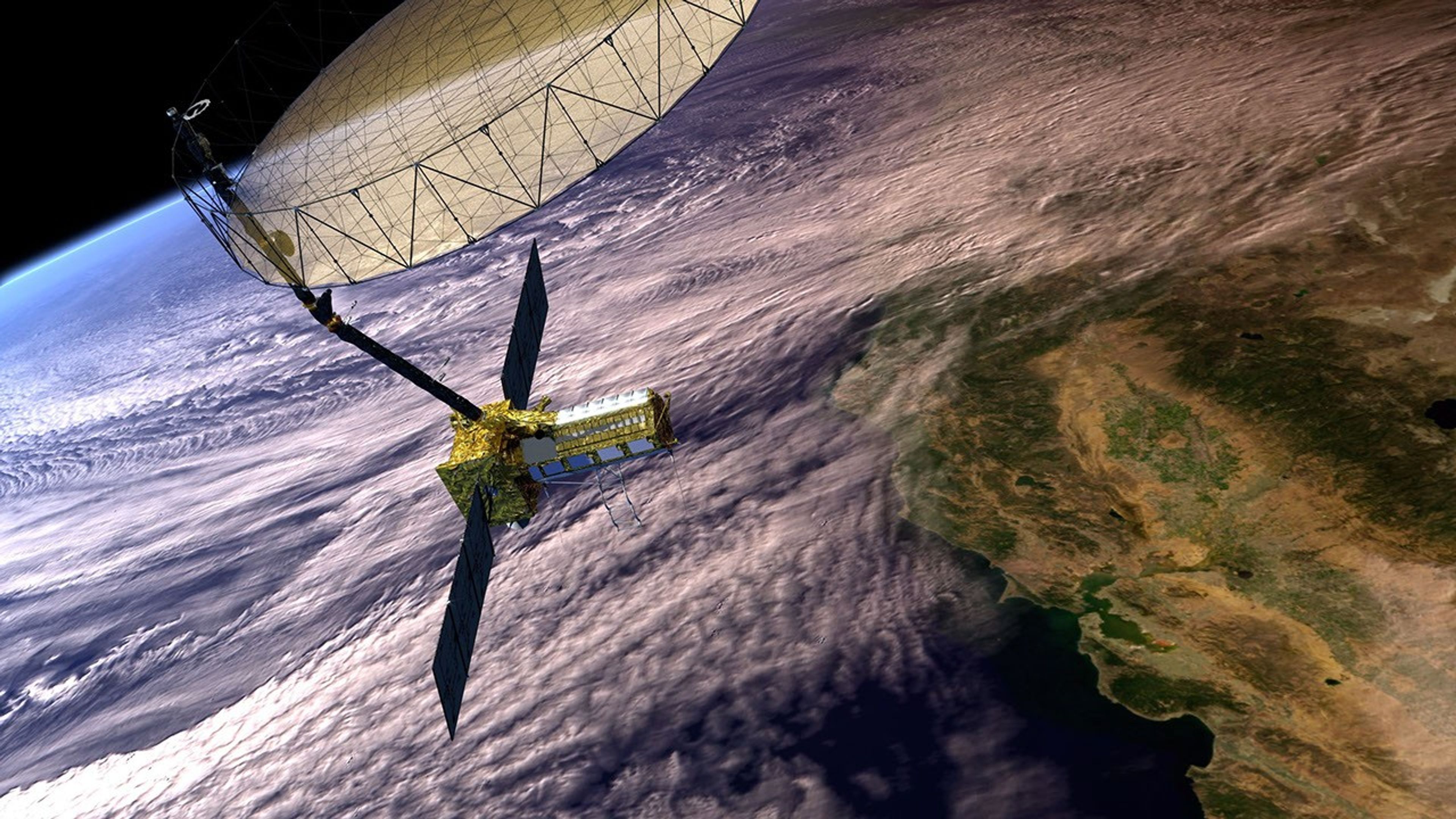
In late February, a NASA aircraft equipped with Uninhabited Aerial Vehicle Synthetic Aperture Radar (UAVSAR) conducted the first of six flights planned for this year, passing over a roughly 25-mile stretch of the Tulare Basin in the San Joaquin Valley, where foothills meet farmland. It’s a zone experts think holds a key to maintaining water supplies for one of America’s most productive agricultural regions.
Much of the San Joaquin Valley’s groundwater comes from the melting of Sierra Nevada snow. “For generations, we’ve been managing water in California without truly knowing where that meltwater seeps underground and replenishes groundwater,” said Stanford University geophysicist and professor Rosemary Knight, who is leading the research.

The process is largely invisible — moisture filtering through rock and sediment, and vanishing beneath orchards and fields. But as the liquid moves downhill, it follows a pattern. Water flows into rivers and streams, some of it eventually seeping underground at the valley’s edge or as the waterways spread into the valley. As the water moves through the ground, it can create slight pressure that in turn pushes the surface upward. The movement is imperceptible to the human eye, but NASA’s advanced radar technology can detect it.
“Synthetic aperture radar doesn’t directly see water,” explained Yunling Lou, who leads the UAVSAR program at NASA’s Jet Propulsion Laboratory in Southern California. “We’re measuring changes in surface elevation — smaller than a centimeter — that tell us where the water is.”
These surface bulges create what Knight calls an “InSAR recharge signature.” By tracking how these surface bulges migrate from the mountains into the valley, the team hopes to pinpoint where groundwater replenishment occurs and, ultimately, quantify the amount of water naturally recharging the system.
Previous research using satellite-based InSAR (Interferometric Synthetic Aperture Radar) has shown that land in the San Joaquin Valley uplifts and subsides with the seasons, as the groundwater is replenished by Sierra snowmelt. But the satellite radar couldn’t uniquely identify the recharge paths. Knight’s team combined the satellite data with images of underground sediments, acquired using an airborne electromagnetic system, and was able to map the major hidden subsurface water pathways responsible for aquifer recharge.
NASA’s airborne UAVSAR system will provide even more detailed data, potentially allowing researchers to have a clearer view of where and how fast water is soaking back into the ground and recharging the depleted aquifers.

Supporting Farmers and Communities
California’s Central Valley produces over a third of America’s vegetables and two-thirds of its fruits and nuts. The southern portion of this agricultural powerhouse is the San Joaquin Valley, where most farming operations rely heavily on groundwater, especially during drought years.
Water managers have occasionally been forced to impose restrictions on groundwater pumping as aquifer levels drop. Some farmers now drill increasingly deeper wells, driving up costs and depleting reserves.
“Knowing where recharge is happening is vital for smart water management,” said Aaron Fukuda, general manager of the Tulare Irrigation District, a water management agency in Tulare County that oversees irrigation and groundwater recharge projects.
“In dry years, when we get limited opportunities, we can direct flood releases to areas that recharge efficiently, avoiding places where water would just evaporate or take too long to soak in,” Fukuda said. “In wetter years, like 2023, it’s even more crucial — we need to move water into the ground as quickly as possible to prevent flooding and maximize the amount absorbed.”
NASA’s Expanding Role in Water Monitoring
NASA’s ongoing work to monitor and manage Earth’s water combines a range of cutting-edge technologies that complement one another, each contributing unique insights into the challenges of groundwater management.
The upcoming NISAR (NASA-ISRO Synthetic Aperture Radar) mission, a joint project between NASA and the Indian Space Research Organisation (ISRO) set to launch in coming months, will provide global-scale radar data to track land and ice surface changes — including signatures of groundwater movement — every 12 days.
In parallel, the GRACE satellites — operated by the German Aerospace Center, German Research Centre for Geosciences, and NASA — have transformed global groundwater monitoring by detecting tiny variations in Earth’s gravity, offering a broad view of monthly water storage changes across large regions.
The Gravity Recovery and Climate Experiment and Follow-On (GRACE and GRACE-FO) missions have helped expose major declines in aquifers, including in California’s Central Valley. But their coarser resolution calls for complementary tools that can, for example, pinpoint recharge hotspots with greater precision.
Together, these technologies form a powerful suite of tools that bridge the gap between regional-scale monitoring and localized water management. NASA’s Western Water Applications Office (WWAO) also plays a key role in ensuring that this wealth of data is accessible to water managers and others, offering platforms like the Visualization of In-situ and Remotely-Sensed Groundwater Observation (VIRGO) dashboard to facilitate informed decision-making.
“Airborne campaigns like this one in the San Joaquin test how our technology can deliver tangible benefits to American communities,” said Stephanie Granger, WWAO’s director at NASA’s Jet Propulsion Laboratory. “We partner with local water managers to evaluate tools that have the potential to strengthen water supplies across the Western United States.”
By Emily DeMarco
NASA Headquarters
Share
Details
Related Terms
Explore More


What's Your Reaction?