


.jpg?#)


NASA Tracks Snowmelt to Improve Water Management
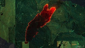
As part of a science mission tracking one of Earth’s most precious resources – water – NASA’s C-20A aircraft conducted a series of seven research flights in March that can help researchers track the process and timeline as snow melts and transforms into a freshwater resource. The agency’s Uninhabited Aerial Vehicle Synthetic Aperture Radar (UAVSAR) […]

3 min read
Preparations for Next Moonwalk Simulations Underway (and Underwater)
As part of a science mission tracking one of Earth’s most precious resources – water – NASA’s C-20A aircraft conducted a series of seven research flights in March that can help researchers track the process and timeline as snow melts and transforms into a freshwater resource. The agency’s Uninhabited Aerial Vehicle Synthetic Aperture Radar (UAVSAR) installed on the aircraft collected measurements of seasonal snow cover and estimate the freshwater contained in it.
“Seasonal snow is a critical resource for drinking water, power generation, supporting multi-billion dollar agricultural and recreation industries,” said Starr Ginn, C-20A project manager at NASA’s Armstrong Flight Research Center in Edwards, California. “Consequently, understanding the distribution of seasonal snow storage and subsequent runoff is essential.”
The Dense UAVSAR Snow Time (DUST) mission mapped snow accumulation over the Sierra Nevada mountains in California and the Rocky Mountains in Idaho. Mission scientists can use these observations to estimate the amount of water stored in that snow.

“Until recently, defining the best method for accurately measuring snow water equivalent (SWE) – or how much and when fresh water is converted from snow – has been a challenge,” said Shadi Oveisgharan, principal investigator of DUST and scientist at NASA’s Jet Propulsion Laboratory in Southern California. “The UAVSAR has been shown to be a good instrument to retrieve SWE data.”
Recent research has shown that snow properties, weather patterns, and seasonal conditions in the American West have been shifting in recent decades. These changes have fundamentally altered previous expectations about snowpack monitoring and forecasts of snow runoff. The DUST mission aims to better track and understand those changes to develop more accurate estimates of snow-to-water conversions and their timelines.
“We are trying to find the optimum window during which to retrieve snow data,” Oveisgharan said. “This estimation will help us better estimate available fresh snow and manage our reservoirs better.”

The DUST mission achieved a new level of snow data accuracy, which is partly due to the specialized flight paths flown by the C-20A. The aircraft’s Platform Precision Autopilot (PPA) enables the team to fly very specific routes at exact altitudes, speeds, and angles so the UAVSAR can more precisely measure terrain changes.
“Imagine the rows made on grass by a lawn mower,” said Joe Piotrowski Jr., operations engineer for NASA Armstrong’s airborne science program. “The PPA system enables the C-20A to make those paths while measuring terrain changes down to the diameter of a centimeter.”
Explore More


What's Your Reaction?